
Utah
One of the fastest growing places in the U.S. are the cities in the Great Salt Lake Rift Valley of Utah. Geological studies clearly demonstrate a record of large earthquakes throughout the recent past in this region. The Wasatch Front is forming by sudden slip of the populated valley off of the Wasatch Range along the Wasatch Fault.
Each fault segment has an earthquake recurrence interval of around 1200 +/- 100 years. Some fault sections, like the Salt Lake City segment, have not experienced a major earthquake in over 1350 +/- 100 years. During this time of frictional energy accumulation enough pressure has built to cause a magnitude 7.0+ earthquake.
Two million people live above the westward inclined fault (see block diagram below) in mostly unreinforced masonry buildings built before seismic codes were established and upgraded in the 1980’s. The majority of schools also 'fall' into this category. Poorly supported critical services, such as gas and water pipelines, bridges and roads, and unstable slopes also pose a significant threat for loss of life and emergency response due to a major earthquake.
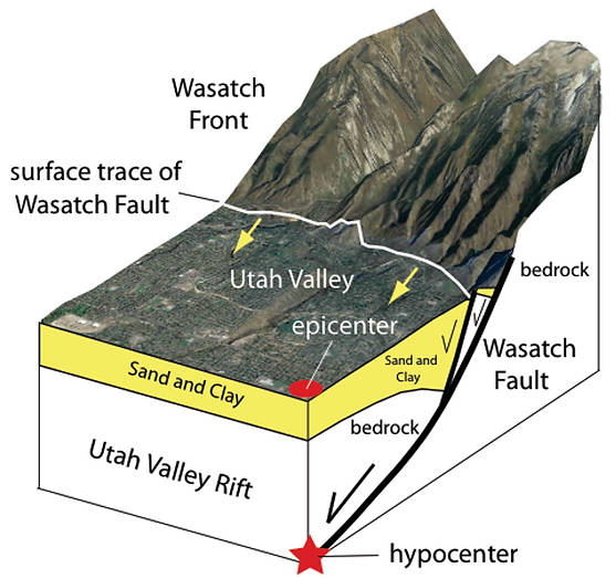
3D Cross section of the Wasatch Front. Note how the Wasatch Fault is inclined under the valley. This configuration is dangerous due to the fact that the epicenter of the earthquake, where most of the energy is released, will likely be in densely populated areas. The hypocenter of the earthquake will also be near the surface. The seismic waves caused by the earthquake will be amplified by the sand and clay the cities are built on.
Seismic Risk in Schools
Many schools in Utah valley were built before seismic code was enforced; thus rendering them extremely vulnerable to ground shaking during an earthquake. To protect students, we have a number of projects that focus on school safety. These projects include:
-
Evaluating the structural safety of schools in Utah County for seismic events.
-
Reducing non-structural hazards (falling objects) in the classroom through appropriate intervention measures.
-
Install earthquake alarms in every classroom and gathering place. Use the alarms often for earthquake drills.
-
Training students and teachers appropriate DUCK, COVER & HOLD strategies when they hear the earthquake alarm of first feel ground motion.
-
Evaluating schools’ disaster and evacuation plans for further improvement related to a seismic event.
-
To the right is a map of Provo schools, represented by stars.
-
Red stars represent schools that are more susceptible to damage by an earthquake
-
Blue starts represent schools that are less susceptible to being damaged by an earthquake.
"We could lose a generation of children if we stay in denial about the seismic vulnerability of Utah school buildings. We do not know how long we have, so we need to act now before it is too late."


The In Harm's Way Community has helped us make positive change! Thanks to the efforts of founder Ron Harris and volunteers like Patti Henwood, schools in Utah were rebuilt to be seismically safe. Read about the story here!
In Harm's Way Efforts in Utah
In Harm's Way is dedicated to educate and prepare those living along the Wasatch Fault of the dangers of the earthquake. Here is what we do:
Assess
-
Past earthquakes on the Wasatch Fault
-
Hi-Res GPS measurements of current loading rate of Wasatch Fault
-
Mapping building site characteristics (shaking intensity and resonant frequencies)
-
Building retrofitting
Advise
-
Presentations involving > 12,000 people in various communities about how to reduce fear of, and prepare in advance for earthquake hazards.
-
Advising government and community leaders about seismic disaster risk reduction
-
Persuading a major University to decommission its seismically vulnerable student dorms and other buildings
Assist
-
Assisting local communities along the Wasatch Front to pass referendums to replace seismically vulnerable schools
-
Map out built dates for neighborhoods and schools (see map above).
-
Earthquake alarms in every classroom

ugs.org

Want to learn about how our research in Indonesia applies to Utah? Check out this KSL Article!
Ongoing Projects in Utah
-
Earthquake preparedness and educational outreach
-
"Fix the Bricks!"
-
We assess at-risk residential buildings to determine what can be done to prevent building collapse during an earthquake.
-
Assessing schools to determine if they will collapse in the event of an earthquake. If they are deemed to be unsafe, we work with the community and school board members to find solutions.
-
-
The Dam Problem
-
Numerical modeling of consequences of catastrophic dam failure during an earthquake
-
-
Interactive Presentations
-
65 presentations along the Wasatch Front at civic, church, and governmental organizations to discuss the importance of earthquake preparedness and safety
-
-
Earthquake Alarms
-
Promoting a community earthquake alarm system with the Utah public safety committee
-
Promoting the installment of simple earthquake alarms in every building- homes, schools, churches, government buildings, and more.
-
-